
Coastal Regulation Zone Classifications
Coastal Regulation Zone Classification 2011
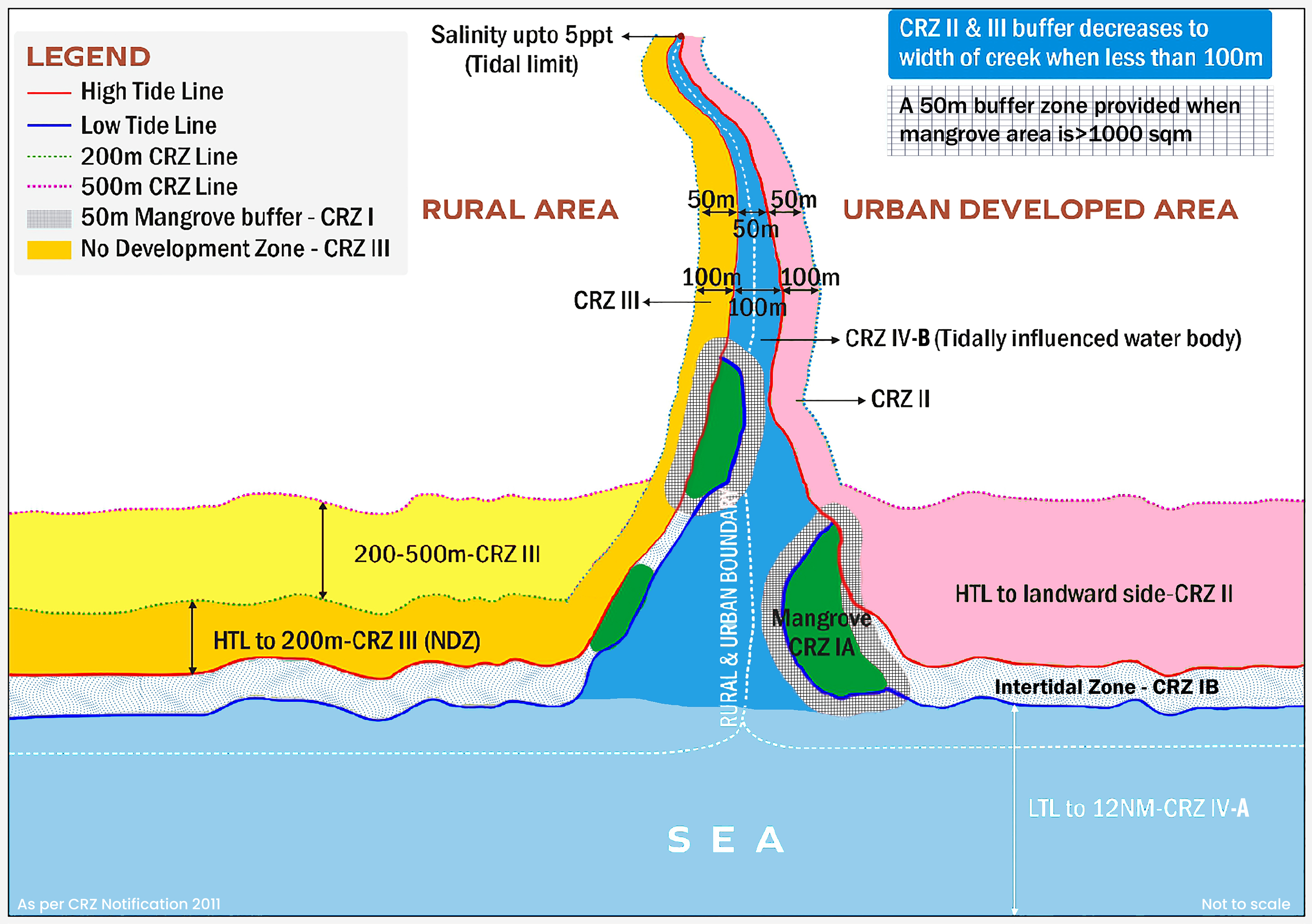
Coastal Regulation Zone (CRZ) area includes the land area from High Tide Line (HTL) to 500 m on the landward side along the sea front, in case of tidal influence waterbodies, the land area between HTL to 100 m or width of the creek, water bodies etc. whichever is less. As per this notification, the coastal areas have been classified into five zones as follows
X
![]()
CRZ-I
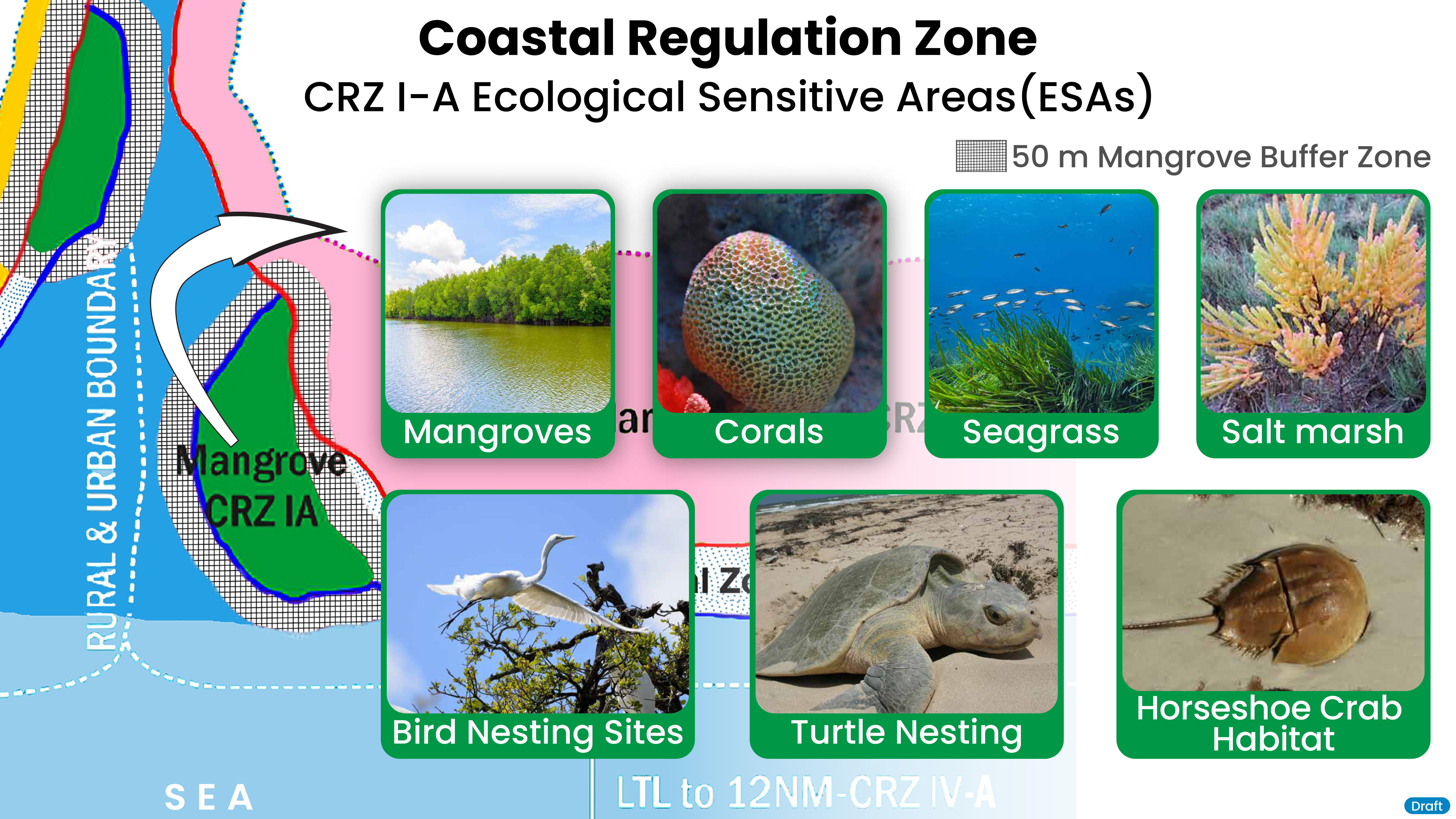
A. The areas that are ecologically sensitive
Mangroves / Corals and coral reefs and associated biodiversity / Sand Dunes / Mud flats/ National parks, marine parks, sanctuaries, reserve forests, wildlife habitats including Biosphere Reserves / Salt Marshes / Turtle nesting grounds / Horse shoe crabs habitats / Sea grass beds / Nesting grounds of birds / Areas or structures of archaeological importance and heritage sites, etc.,
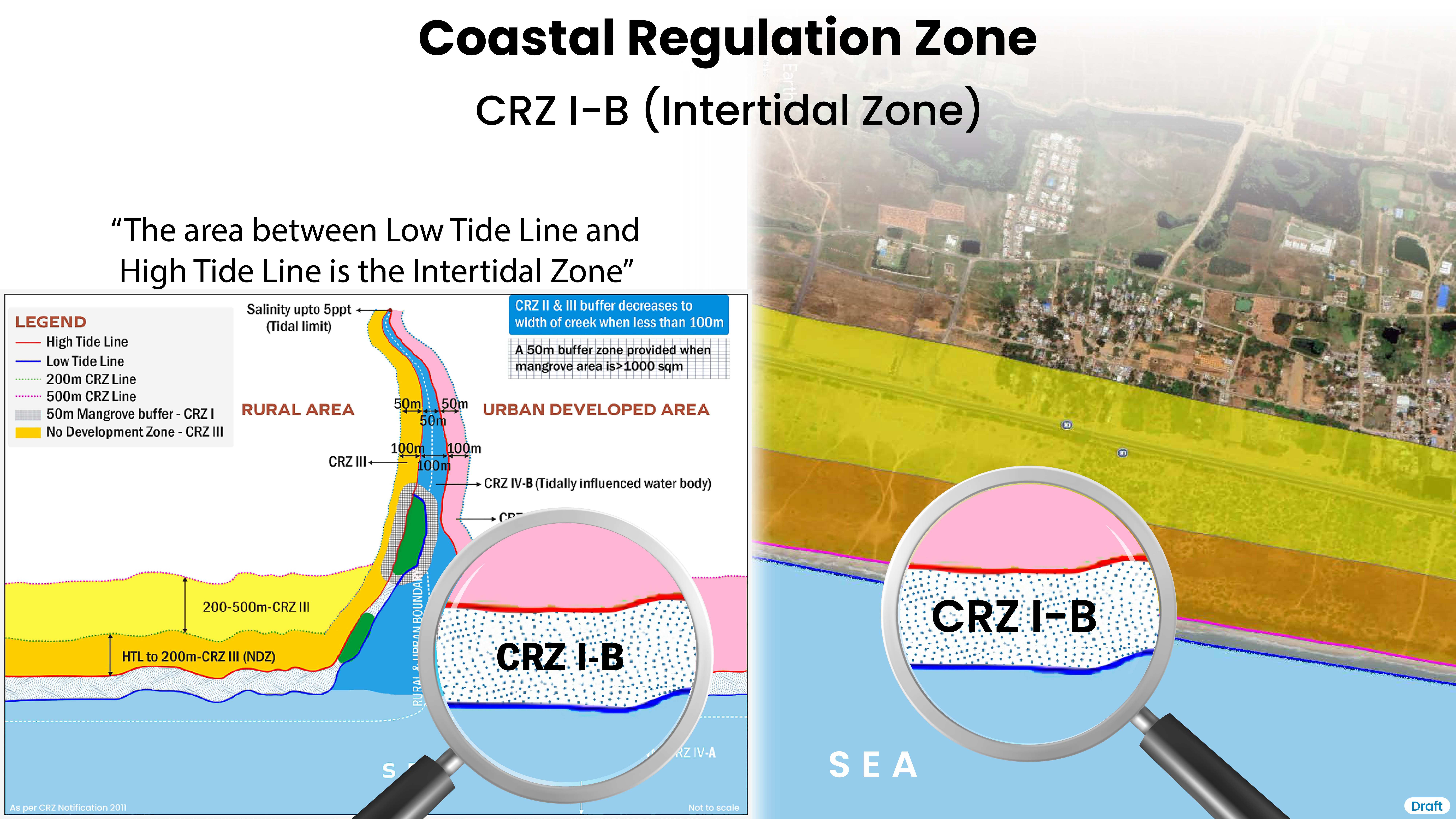
B. The area between Low Tide Line and High Tide Line (inter tidal zone)
X
![]()
X
![]()
Regulation of Permissible Activities in CRZ - I as per CRZ Notification 2011
- (a) projects relating to Department of Atomic Energy
- (b) pipelines, conveying systems including transmission lines
- (c) facilities that are essential for activities permissible under CRZ-I
- (d) installation of weather radar for monitoring of cyclones movement and prediction by Indian Meteorological Department
- (e) construction of trans harbour sea link and without affecting the tidal flow of water, between LTL and HTL.
- (f) development of green field airport already approved at only Navi Mumbai
- (g) projects relating to Defence organisations which are of strategic requirement and national importance and cannot be located elsewhere, subject to strict environmental safe guards.
(i) no new construction shall be permitted in CRZI except,
- (a) exploration and extraction of natural gas
- (b) construction of dispensaries, schools, public rain shelter, community toilets, bridges, roads, jetties, [erosion control measures]*40 water supply, drainage, sewerage which are required for traditional inhabitants living within the biosphere reserves after obtaining approval from concerned CZMA.
- (c) necessary safety measure shall be incorporated while permitting such developmental activities in the area falling in the hazard zone.
- (d) salt harvesting by solar evaporation of seawater.
- (e) desalination plants.
- (f) storage of non-hazardous cargo such as edible oil, fertilizers and food grain within notified ports.
- (g) construction of trans harbour sea links, roads on stilts or pillars without affecting the tidal flow of water.
- (h) Manual mining of atomic mineral(s) notified under Part-B of First Schedule of Mining and Minerals (Development) Act, 1957 occurring as such or in association with one or other minerals - in the inter-tidal zone by such agencies as authorised by Department of Atomic Energy, as per mining plan approved by the Department of Atomic Energy.
(ii)Are as between LTL and HTL which are not ecologically sensitive, necessary safety measures will be incorporated while permitting the following, namely:
{Provided that the manual mining operations are carried out only by deploying persons using baskets and hand spades for collection of ore or mineral within the intertidal zone and as per approved mining plan. Explanation. - For the purpose of this notification, manual mining shall mean the mining operations undertaken without deploying or using drilling and blasting or Heavy Earth Moving machinery in the intertidal zone.}
CRZ-II
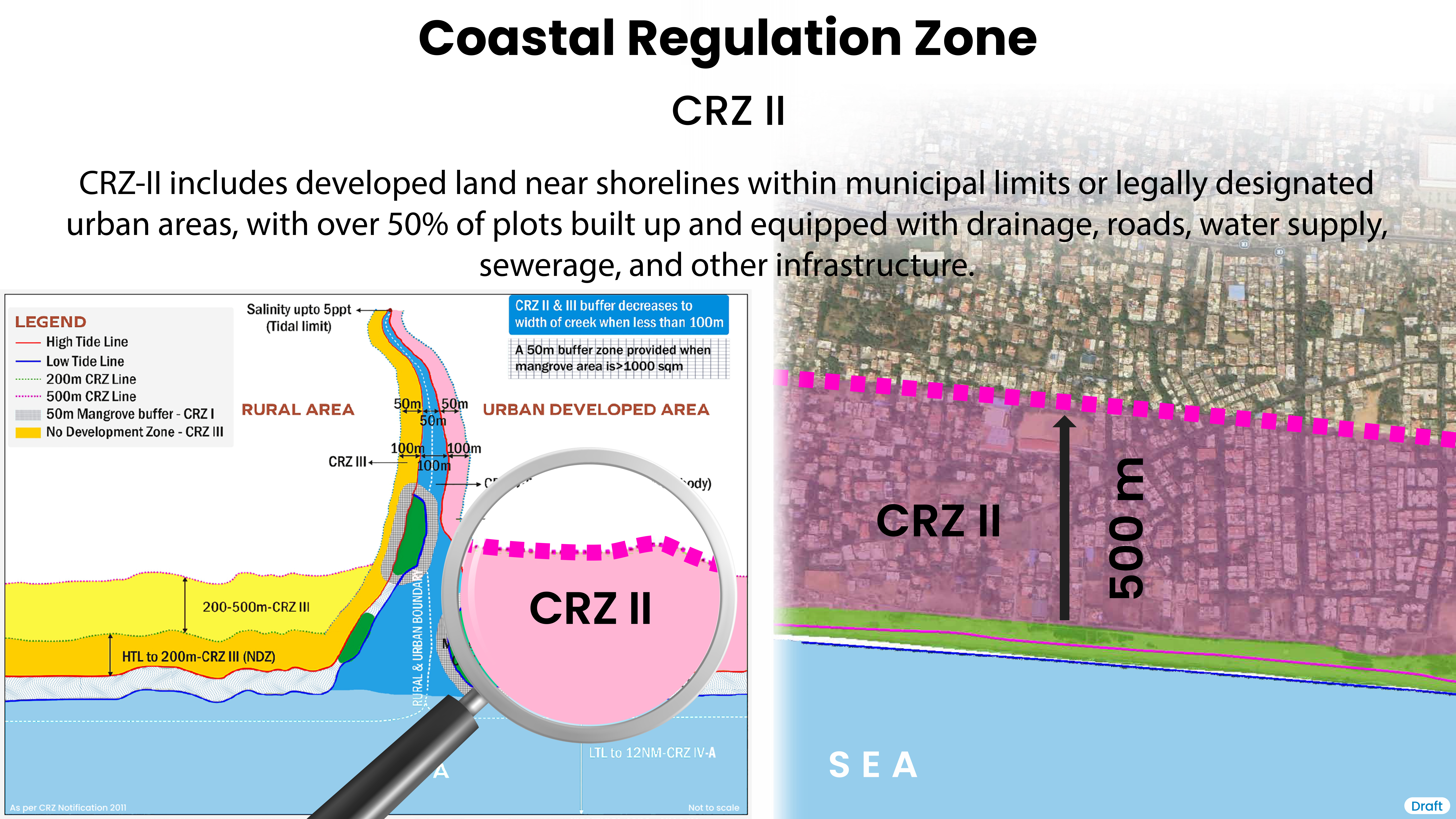
The areas that have been developed upto or close to the shoreline.
Explanation - (For the purposes of the) expression "developed area" is referred as the area within the existing municipal limits or in other existing legally designated urban areas which are substantially built-up and has been provided with drainage and approach roads and other infrastructural facilities, such as water supply and sewerage mains
X
![]()
Regulation of Permissible Activities in CRZ - II as per CRZ Notification 2011
- (i) buildings shall be permitted only on the landward side of the existing road, or on the landward side of existing authorized structures.
- (ii) buildings permitted on the landward side of the existing and proposed roads or existing authorised structures shall be subject to the existing local town and country planning regulations as modified from time to time, except the Floor Space Index or Floor Area Ratio, which shall be as per 1991 level :
Provided that no permission for construction of buildings shall be given on landward side of any new roads which are constructed on the seaward side of an existing road. - (iii) reconstruction of authorized building to be permitted subject with the existing Floor Space Index or Floor Area Ratio Norms and without change in present use.
- (iv) facilities for receipt and storage of petroleum products and liquefied natural gas as specified in Annexure-II of CRZ Notification, 2011 and facilities for regasification of Liquefied Natural Gas subject to the conditions as mentioned in sub-paragraph (ii) of paragraph 3 of CRZ Notification, 2011.
- (v) desalination plants and associated facilities.
- (vi) storage of non-hazardous cargo, such as edible oil, fertilizers and food grain in notified ports.
- (vii) facilities for generating power by non-conventional power sources and associated facilities.
CRZ-II
CRZ-III
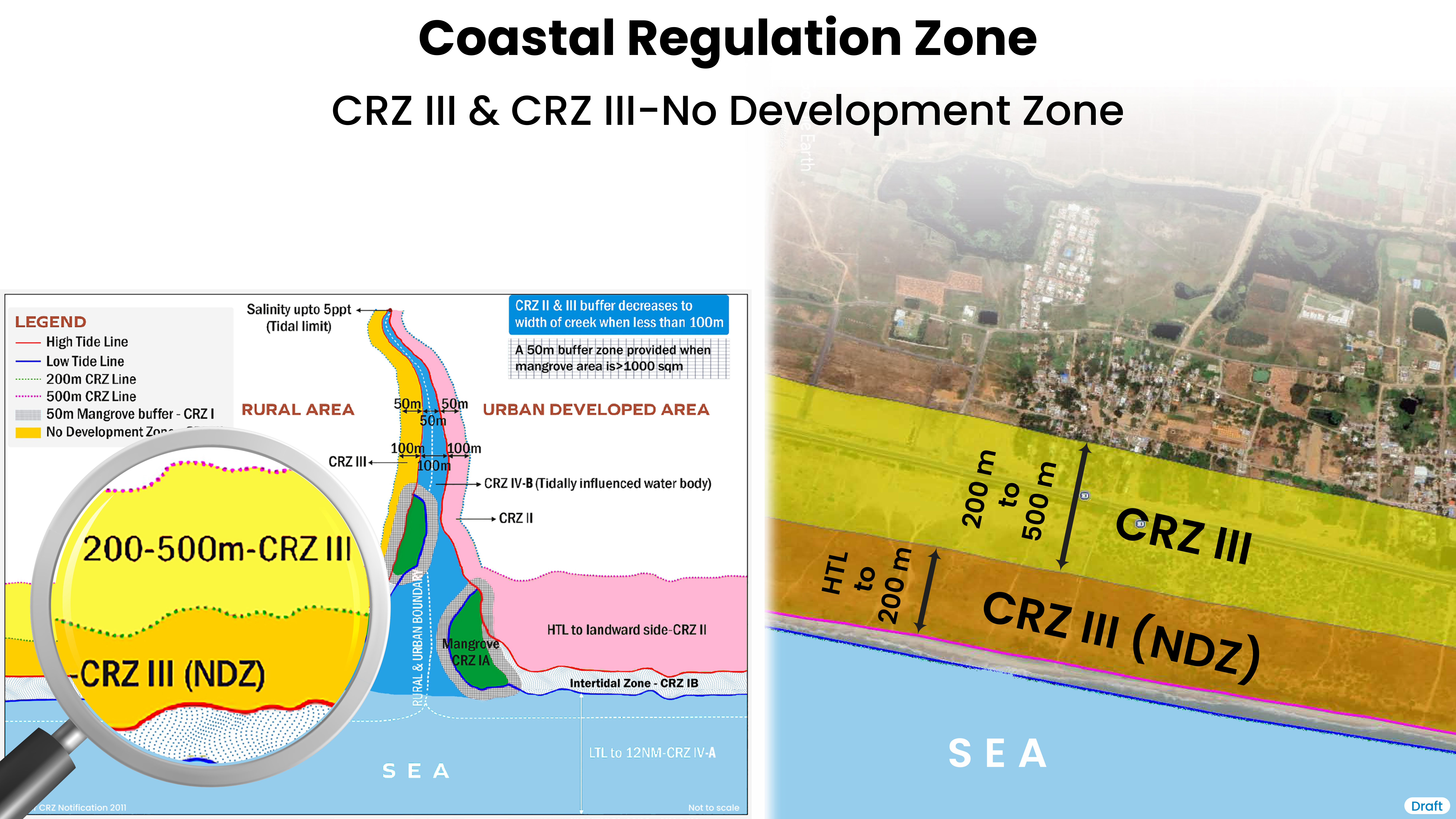
Areas that are relatively undisturbed and those do not belong to either CRZ-I or II which include coastal zone in the rural areas (developed and undeveloped) and also areas within municipal limits or in other legally designated urban areas, which are not substantially built up.
3A. Area upto 200mts from HTL on the landward side in case of seafront and 100mts along tidal influenced water bodies or width of the creek whichever is less to be earmarked as No "Development Zone" (NDZ)
3B. Area between 200mts to 500mts
X
![]()
Regulation of Permissible Activities in CRZ - III as per CRZ Notification 2011
- (i) the NDZ shall not be applicable in such area falling within any notified port limits.
- (ii)No construction shall be permitted within NDZ except for repairs or reconstruction of existing authorized structure not exceeding existing Floor Space Index, existing plinth area and existing density and for permissible activities under the notification especially facilities essential for activities; Construction/reconstruction of dwelling units of traditional coastal communities including fisherfolk may be permitted between 100 and 200 metres from the HTL along the seafront in accordance with a comprehensive plan prepared by the State Government or the Union territory in consultation with the traditional coastal communities especially fisherfolk and incorporating the necessary disaster management provision, sanitation and recommended by the concerned State or the Union territory CZMA to NCZMA for approval by MoEF;
- (iii) however, the following activities may be permitted in NDZ -
- (a) agriculture, horticulture, gardens, pasture, parks, play field, and forestry.
- (b) projects relating to Department of Atomic Energy.
- (c) Mining of atomic minerals notified under part B of the first schedule of the mining and minerals (development) Act, 1957 occurring as such or in association with one or other minerals
- (d) salt manufacture from seawater.
- (e) facilities for receipt and storage of petroleum products and liquefied natural gas as specified in Annexure-II of CRZ Notification, 2011.
- (f) facilities for regasification of liquefied natural gas subject to conditions as mentioned in subparagraph (ii) of paragraph 3 of CRZ Notification, 2011.
- (g) facilities for generating power by non-conventional energy sources.
- (h) Foreshore facilities for desalination plants and associated facilities.
- (i) weather radars.
- (j) construction of dispensaries, schools, public rain shelter, community toilets, bridges, roads, provision of facilities for water supply, drainage, sewerage, crematoria, cemeteries and electric sub-station which are required for the local inhabitants may be permitted on a case to case basis by CZMA.
- (k) construction of units or auxiliary thereto for domestic sewage treatment and disposal with the prior approval of the concerned Pollution Control Board or Committee.
- (l) facilities required for local fishing communities such as fish drying yards, auction halls, net mending yards, traditional boat building yards, ice plant, ice crushing units, fish curing facilities and the like.
- (m) development of green field airport already permitted only at Navi Mumbai.
A. Area upto 200mts from HTL on the landward side in case of seafront and 100mts along tidal influenced water bodies or width of the creek whichever is less is to be earmarked as "No Development Zone (NDZ)", -
- (i) development of vacant plot in designated areas for construction of hotels or beach resorts for tourists or visitors subject to the conditions as specified in the guidelines at Annexure-III of CRZ Notification, 2011.
- (ii) facilities for receipt and storage of petroleum products and liquefied natural gas as specified in Annexure-II of CRZ Notification, 2011.
- (iii) facilities for regasification of liquefied natural gas subject to conditions as mentioned in sub-paragraph (ii) of paragraph 3 of CRZ Notification, 2011.
- (iv) storage of non-hazardous cargo such as, edible oil, fertilizers, food grain in notified ports.
- (v) foreshore facilities for desalination plants and associated facilities.
- (vi) facilities for generating power by non-conventional energy sources.
- (vii) construction or reconstruction of dwelling units so long it is within the ambit of traditional rights and customary uses such as existing fishing villages and goathans. Building permission for such construction or reconstruction will be subject to local town and country planning rules with overall height of construction not exceeding 9mts with two floors (ground + one floor).
- (viii) Construction of public rain shelters, community toilets, water supply drainage, sewerage, roads and bridges by CZMA who m a y also permit construction of schools and dispensaries for local inhabitants of the area for those panchayats, the major part of which falls within CRZ if no other area is available for construction of such facilities.
- (ix) reconstruction or alteration of existing authourised building subject to sub-paragraph (vii),(viii).
- (x) development of green field airport already permitted only at Navi Mumbai.
- (xi) Mining of atomic minerals notified under part B of the first schedule of the mining and minerals (development) Act, 1957 occurring as such or in association with one or other minerals.
B. Area between 200mts to 500 mts,-
The following activities shall be permissible in the above areas.
CRZ-IV
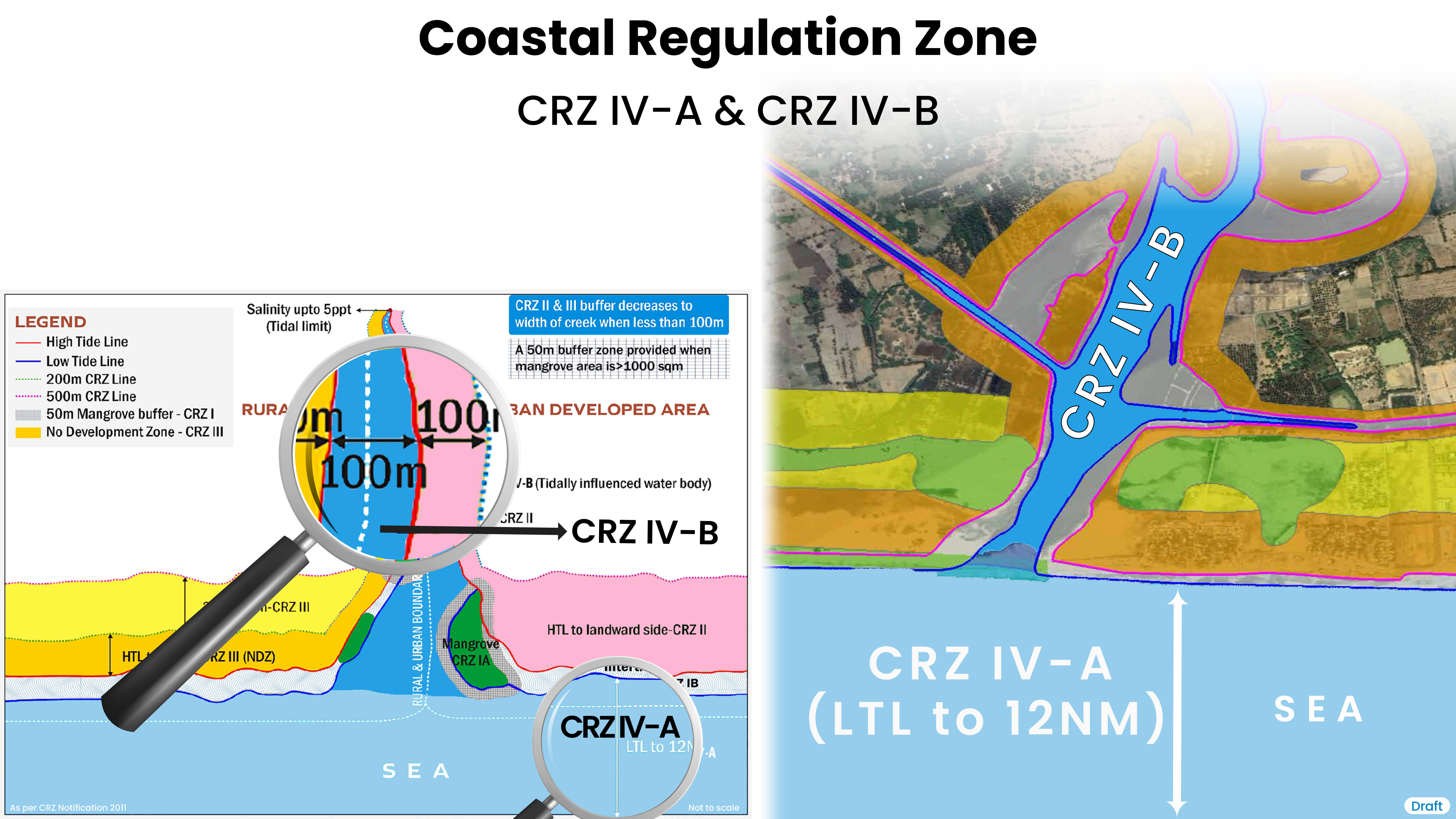
A.The water area from the Low Tide Line to twelve nautical miles on the seaward side
B.The water area of the tidal influenced water body from the mouth of the water body at the sea upto the influence of tide which is measured as five parts per thousand during the driest season of the year.
X
![]()
Regulation of Permissible Activities in CRZ - IV as per CRZ Notification 2011
- (a) No untreated sewage, effluents, ballast water, ship washes, fly ash or solid waste from all activities including from aquaculture operations shall be let off or dumped. A comprehensive plan for treatment of sewage generating from the coastal towns and cities shall be formulated within a period of one year in consultation with stakeholders including traditional coastal communities, traditional fisherfolk and implemented.
- (b) Pollution from oil and gas exploration and drilling, mining, boat house and shipping.
- (c) There shall be no restriction on the traditional fishing and allied activities undertaken by local communities.
CRZ-IV
The activities impinging on the sea and tidal influenced water bodies will be regulated except for traditional fishing and related activities undertaken by local communities as follows:-
CRZ-V
Areas requiring special consideration for the purpose of protecting the critical coastal environment and difficulties faced by local communities and the Critically Vulnerable Coastal Areas (CVCA) such as Sunderbans region of West Bengal and other ecologically sensitive areas identified as under Environment (Protection) Act, 1986 and managed with the involvement of coastal communities including fisherfolk.
